
Montenegro TOP 10 – 10 Best Hiking Routes
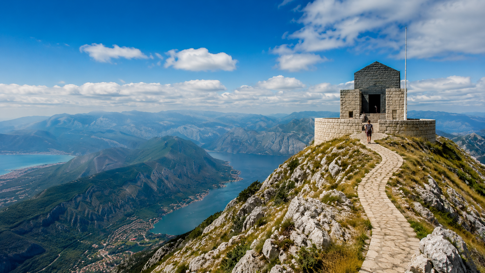
Places that look close together on a map can still involve long drives on Montenegro’s mountain roads, and within a few hours you can move from the coast to terrain at 1,500–2,000 metres. A good hiking plan here is therefore not about fitting in as many sights as possible, but about choosing a route that matches the terrain, elevation gain and the weather on that particular day.
- For an easy first dayCrno jezero, Biogradsko jezero or Ćurevac: short walks, big scenery and little elevation gain.
- Always check elevation as well as distanceVolušnica may be only 6–7 km long, but more than 700 m of climbing makes it a much bigger day than a 10 km forest walk.
- The coast and the high mountains are different worldsKotor can be in summer heat while Durmitor has wind, fog or lingering snow patches.
- The trailhead changes the hikeThe same lake or viewpoint may have a 2 km option and an all-day route from a different starting point.
- Offline map + cashBoth are useful in remote parks, where mobile coverage and card payment are not guaranteed everywhere.
In Montenegro, the trailhead can matter as much as the destination
Six details worth checking before you choose the route
Distance alone tells you very little.| Topic | What to know |
|---|---|
| Payment | Montenegro uses the euro. Cards are widely accepted in towns, but carry cash for park entry, smaller car parks and mountain cafés or guesthouses. |
| Driving | Mountain roads are winding and often narrow. A transfer of 60–80 km can therefore take much longer than the distance suggests. |
| Trailhead | Compare distance and elevation from the same starting point. Ćurevac, for example, has a short walk from a nearby car park as well as a much longer route starting in Žabljak. |
| Waymarks | Red-and-white circular waymarks are common, but do not rely on paint alone. Keep the route available offline at junctions. |
| Park entry | National park fees and entry points can change. Check the current price and opening information on the park’s official website before setting out. |
| Altitude | Weather on the coast and at 1,500–2,000 metres can be very different on the same day, so check a mountain forecast separately. |
The figures in this article describe one specific version suitable for an average hiker. The same attraction may have a much longer approach from another car park or via a different connecting trail.
Who is this TOP 10 for?
Regular hikers, not high-mountain peak baggers.The list is designed so that most routes can be completed in 1–5 hours without technical climbing or via ferrata skills. On the harder options, the main challenge is elevation gain, distance or steeper mountain terrain.
That is why several famous objectives — such as Bobotov kuk or the long Durmitor Ice Cave high-mountain circuit — are deliberately left out. They are spectacular, but require a different level of preparation.
Durmitor: real high-mountain scenery on a short hike
The lakeside and viewpoint trails are an excellent first introduction to the range.
You do not need to start with a summit hike in Durmitor. The lakes and shorter panoramic routes reveal the character of the limestone peaks with relatively little elevation gain.
The first five: lakes, Tara Canyon and the Bay of Kotor
The full top ten in one table
A quick way to compare distance, elevation and difficulty.| # | Route | Distance | Elevation | Difficulty |
|---|---|---|---|---|
| 1 | Crno jezero circuit — Durmitor | approx. 3.6 km | approx. 50 m | Easy |
| 2 | Biogradsko jezero circuit | approx. 3.4 km | approx. 30–40 m | Easy |
| 3 | Ćurevac — Tara Canyon viewpoint | approx. 2.2 km | approx. 70 m | Easy |
| 4 | Kotor Fortress — San Giovanni | approx. 4–5 km | approx. 300–400 m | Moderate |
| 5 | Fort Vrmac above Kotor | approx. 8.5 km | approx. 500 m | Moderate |
| 6 | Ivanova Korita — Zlatarice, Lovćen | approx. 9.7 km | approx. +300 m | Moderate |
| 7 | Mrtvica Canyon | approx. 6.5–12 km | approx. 250–350 m | Moderate |
| 8 | Pešića Lake — from Zekova glava | approx. 5 km | approx. 250 m | Easy–moderate |
| 9 | Crno jezero — Zminje jezero | approx. 10 km | approx. 120–150 m | Easy–moderate |
| 10 | Volušnica — Grebaje Valley | approx. 6.5–7 km | approx. 750–800 m | Upper moderate |
1. Crno jezero circuit — Durmitor National Park
The easiest way to enter the world of Durmitor on foot.The Black Lake circuit is short but varied: pine forest, lakeside trail and smaller rocky or root-covered sections alternate, with the Međed massif rising above you almost the entire way. It makes a better first day than immediately heading for a high summit, because you can see the landscape while also judging the weather and trail conditions.
The lake level changes with the season, so the section between the two basins can look very different in late summer than after snowmelt. If you have more time, it is easy to continue from here towards Zminje jezero.
2. Biogradsko jezero circuit — Biogradska Gora
Primeval forest, boardwalks and lakeside trail with almost no climbing.Most of the route around the lake stays in forest, making it one of the best alternatives when the higher mountains are cloudy or windy. The terrain is simple but continuously interesting: old beech trees, fallen trunks, wetlands and the slopes of Bjelasica surround the lake.
Boardwalks and roots can be slippery after rain, but there is no serious elevation gain. If the lakeside loop feels too short, several longer routes continue deeper into Bjelasica.
3. Ćurevac — Tara Canyon viewpoint
A short walk to one of the best panoramas over Tara Canyon.The short version starts from the car park on the Nadgora side and leads through forest to the edge of Ćurevac. Near the end you are directly above Tara Canyon, so despite the short distance it feels far more mountainous than a simple roadside viewpoint.
The final section is rocky and in places runs close to the canyon edge. It can be slippery when wet. A much longer circuit also reaches Ćurevac from Žabljak, which is exactly why you should check the chosen route rather than relying on the destination name alone.
4. Kotor Fortress — San Giovanni
Short distance, substantial climbing and continuous views over the bay.The fortifications climb the hillside directly behind the old town. The challenge is not technical terrain, but the large number of steps, stone surfaces and summer heat. The view over the Bay of Kotor opens steadily as you climb, making this a strong option even when you only have half a day.
Entry arrangements and the use of individual gates can change seasonally, so do not build your plan around a specific rear access point. Check current local information before setting out.
5. Fort Vrmac above Kotor
A quieter alternative when you want Bay of Kotor views without the staircase.The trail on the Vrmac ridge climbs in long switchbacks, so the elevation is distributed more evenly than on the fortress steps in Kotor. The objective is the old Austro-Hungarian fort, but the main attraction is really the dual view towards both Kotor and Tivat.
The fort is a ruined structure, so treat this as a scenic hike rather than an urban-exploration destination: do not enter dark, damaged or structurally uncertain interior sections.
Kotor: few kilometres, rapidly accumulating elevation
On the routes above the bay, steps, stone and summer heat all contribute to the effort.
Kotor’s routes can look short on the map, but the steep mountainside means the elevation builds quickly. In summer, the same 4–5 kilometres can feel much harder than in cooler weather.
The second five: Lovćen, canyon, Bjelasica and Prokletije
6. Ivanova Korita — Zlatarice, Lovćen
It starts in forest, crosses high plateau terrain and finishes near the upper station of the Kotor–Lovćen cable car.This route is interesting because it does not turn the mausoleum steps into a “hike”. Instead, it provides a genuine walking traverse through the interior of Lovćen. Beech forest, katuns and more open mountain terrain alternate, with views towards the sea from several points.
It is a point-to-point route, so plan your return transport in advance. Cable-car operation, transfers and current road conditions all affect which logistics are easiest.
7. Mrtvica Canyon
A rock-cut path, stone bridge and turquoise water — but current trail conditions matter here.Mrtvica is not one fixed “12 km circuit”, but a canyon route that can be walked in several different lengths. Highlights include the old Danilo Bridge, springs and sections of trail cut into the rock wall. On longer variants, the return route and the condition of crossings matter.
Bridges on some longer canyon routes were damaged by flooding in 2020, and later reports indicated that not every crossing had been restored. Local tourist information or a recent route report is more useful here than a guide written several years ago.
8. Pešića Lake — Bjelasica
A high-mountain lake with relatively little climbing when the higher trailhead is accessible.Pešića Lake lies above 1,800 metres, yet it can still be a relatively easy hike when approached from the higher trailhead near the Kolašin 1600 ski area. Bjelasica is grassier and more open than Durmitor’s limestone terrain, so the landscape feels completely different.
Access is the key detail here: lifts and mountain roads may operate seasonally. Starting lower down turns the same lake into a much longer hike with more elevation gain.
9. Crno jezero — Zminje jezero
The quieter side of Durmitor: two lakes in one forest half-day.If the Crno jezero loop feels too short, continuing towards Zminje jezero is the most natural next step. The route stays mostly in forest, gains little elevation and quickly becomes much quieter than the immediate Black Lake area.
Roots and earth sections can become slippery after rain, but there are no exposed high-mountain sections. It is also a useful option when the summits are in cloud but the lower forest zone remains walkable.
10. Volušnica — Grebaje Valley, Prokletije
Short but steep: the highest elevation gain per kilometre in this list.Volušnica climbs a lot over a short distance above the Grebaje Valley, so the kilometre figure is misleading. The first section rises through forest before the view opens towards the Karanfili rock walls and the mountains along the Albanian border.
It is a physically demanding day even without technical climbing. If short, steep ascents are not your strength, stay on the floor of the Grebaje Valley: the dramatic rock amphitheatre is already visible from there.
When you want more than an easy lake circuit
Forest-and-lake routes are a useful step between a short walk and a serious high-mountain day.
At this point it is worth using proper hiking footwear, an offline map and a specific route track, but the easier and moderate routes in this article still require no technical climbing.
The same “moderate” rating can mean three very different things
Choose according to what tires you first
Some hikers struggle with distance, others with steepness or heat.Routes 1, 2 and 3
Crno jezero, Biogradsko jezero and Ćurevac. Fitness is not the main issue on these routes; the real question is how much time you want to spend in the area.
Routes 4, 5, 6, 8 and 9
Half-day outings, mostly with around 300–500 metres of ascent or less. Their challenge comes from steps, sun exposure, longer walking or logistics rather than technical terrain.
Routes 7 and 10
Mrtvica Canyon needs more attention because of terrain and route conditions, while Volušnica is demanding because of its steep climb of around 750 metres.
Durmitor’s current official Ice Cave–Planinica–Zminje jezero circuit is more than 23 km long with over 1,800 metres of total ascent. Bobotov kuk is also not an “average half-day hike”. These objectives deserve a separate article rather than being compressed into a beginner-friendly TOP 10.
Treat the coast and the 2,000-metre mountains as separate hiking seasons
The seasons from a hiker’s point of view
The best month depends on whether Kotor or Durmitor is your main objective.| Period | Coast, Kotor, Lovćen | Durmitor, Bjelasica, Prokletije |
|---|---|---|
| April–May | Can be excellent walking weather with fewer visitors. | Snow, meltwater and muddy trails can still remain at higher elevations. |
| June | Temperatures rise, so starting time begins to matter on open rocky routes. | A transitional month: many routes are walkable, but snow patches may remain higher up. |
| July–August | Morning is more comfortable for low, exposed routes. | Main high-mountain season, although thunderstorms and strong sun are both possible. |
| September | More comfortable temperatures and usually fewer visitors. | Often one of the best periods: access is still good, but summer heat is less intense. |
| October | Many lower routes can still be good choices. | Shorter daylight, colder mornings and rapidly changing mountain weather. |
| November–March | Some lower hikes may remain possible depending on the weather. | Expect winter conditions, snow and icy sections; this requires different equipment and experience. |
For mountain routes, check wind gusts, hourly precipitation timing, cloud cover and the temperature at higher elevation. A coastal city forecast does not tell you what conditions will be like at 1,800–2,000 metres.
Montenegro is more than Durmitor
The lake districts, coast and high mountains can feel completely different on the same trip.
Treat both season and daily weather by region. Conditions that are comfortable by a lake or the bay may be much cooler, foggier or windier higher in the mountains.
On three routes, logistics matter more than the walking itself
What to check before leaving your accommodation
Not a packing list, but the details that can genuinely change your day.If you are visiting several regions, a car is the most practical option, but avoid planning a long transfer every day. Kotor, Kolašin and Žabljak are three good bases; for a one-week trip, two are usually enough.
Most problems come from poor timing or route choice, not exotic hazards
Five things genuinely worth taking seriously in Montenegro
They are more relevant than a long list of unlikely dangers.Open low-level karst can drain your energy quickly
Some routes around Kotor and Lovćen have very little shade. Do not plan the same pace for a cool September day and a hot July day.
Wind and fog can slow you before the rain does
On Durmitor and in Prokletije, cloud base and wind gusts directly affect how easy the route is to follow and how comfortable it feels.
Old descriptions can become outdated after floods or rockfall
In canyons, around bridges and on steep mountain access roads, always check whether there is newer local information about current conditions.
| Topic | What should you do? |
|---|---|
| Emergency call | 112 is the national emergency number throughout Montenegro. If possible, give your phone’s GPS coordinates as well. |
| Insurance | Choose travel insurance that covers hiking and, if necessary, mountain rescue up to the elevation you plan to reach. |
| Route data | Do not save only a screenshot: keep a downloaded map and a usable GPX track or offline route. |
| Return transport | For point-to-point hikes, know how you will get back before setting out. Finding a spontaneous taxi at a remote mountain car park may not be easy. |
| Slippery rock | Limestone, roots and polished stone steps become much more slippery in rain. Your planned walking time will also increase. |
Turn the TOP 10 into a real trip instead of hours of driving every day
Three itineraries that make sense
Fewer bases, more walking.| Length | Base | Sensible plan |
|---|---|---|
| 3 days | Kotor | Day 1: Kotor Fortress · Day 2: Vrmac · Day 3: Lovćen. Three different routes without long transfers. |
| 5 days | Kotor + Žabljak | Two days around the bay, then Crno jezero, Ćurevac and Zminje jezero in the north. It is also easier to reshuffle the plan if one day has poor weather. |
| 7–8 days | Kotor + Kolašin + Žabljak | Bay of Kotor and Lovćen, then Biogradsko jezero / Pešića Lake / Mrtvica, followed by Durmitor. Prokletije only fits comfortably if you are happy to add another transfer. |
Prokletije is spectacular, but Gusinje is a separate detour. If you want both the Bay of Kotor and Durmitor in one week, you do not necessarily need to force every famous region into the same trip.
Frequently asked questions
Short answers for planning your trip.Do Hungarian citizens need a passport or visa?
According to the current information from Montenegro’s Ministry of Foreign Affairs, Hungarian citizens may stay visa-free for up to 30 days with a valid national ID card and up to 90 days with a valid passport. Check the current rule before travelling.
Which three routes are best for a first hiking trip to Montenegro?
Crno jezero, Ćurevac and Vrmac make a strong combination: you get a lake, high-mountain scenery, a Tara Canyon panorama and the Bay of Kotor without technical mountaineering.
Do I need a mountain guide for the routes in this article?
Usually not in normal summer conditions. Higher Durmitor summits, winter terrain or less clearly marked routes in Prokletije are a different category.
Can I hike without a car?
Several routes around Kotor and Žabljak are accessible on foot or with a short local transfer, but a car gives much more flexibility for the country’s wider hiking network. Public transport to remote trailheads is limited.
Which route should I choose in poorer mountain weather?
Instead of an exposed high ridge, the lower, more wooded surroundings of Biogradsko jezero or Crno jezero may be better options, although current local conditions still decide whether they are suitable during thunderstorms or strong winds.
Which hike gives the most scenery for the least walking?
The short car-park version of Ćurevac. In roughly an hour of walking, you reach one of the best panoramas directly above Tara Canyon.
In Montenegro, the same destination can describe several completely different hikes.
Always check the exact trailhead, distance, elevation and whether the route is a circuit or point to point. That way you choose an actual hike that suits you, not just the name of a famous place.
Kotor + Žabljak is the simplest two-base combination.
One gives you the karst and fortifications above the bay; the other gives you Durmitor’s lakes and Tara Canyon. If you have another two days, Kolašin and Biogradska Gora add a third, completely different landscape.
Sources and background
Official and local primary sources for checking travel, route, weather and safety information.
- National Parks of Montenegro — official website
- Official Montenegro tourism portal
- Official Montenegro tourism portal — currency and payments
- Montenegro Ministry of Foreign Affairs — entry rules for Hungarian citizens
- Montenegro Ministry of the Interior — 112 emergency number
- TO Žabljak — Ćurevac route
- Durmitor Ring — official map and Ćurevac information
- TO Kolašin — Mrtvica Canyon
- Montenegro Travel / NP Biogradska Gora — Pešića Lake route
- ZHMS Montenegro — official weather service
- MeteoAlarm — European warning map
- Dana Verdes / Pexels — free-to-use Pexels photo
- Julien Goettelmann / Pexels — free-to-use Pexels photo
- Mladen Janic / Pexels — free-to-use Pexels photo
- M. Emin Bilir / Pexels — free-to-use Pexels photo